If you’ve travelled through the northern parts of Pakistan, you’re
probably aware of the hair-raising hairpin turns that dot the valleys
and mountains there. From the Karakoram Highway to the Fairy Meadows,
Shimshal, Gilgit, Kaghan, Shandur and Shounter valleys, there’s no place
we haven’t combed to bring you this collection of the most dangerous
roads of Pakistan.
Treacherous Tracks of Pakistan for Thrill Seekers
If you’re a thrill seeker looking for your next adrenaline rush, here
are some of the most perilous roads in Pakistan that you can traverse
in a 4×4.
Karakoram Highway
Fairy Meadows Track
Shimshal Valley Road
Jalkhad-Sharda Road
Gilgit-Skardu Road
Shounter Pass
Babusar Pass
Shandur Pass
We’ll elaborate a little on each of these routes below to give you an
idea of why they have scored a spot on our list of the most dangerous
roads of Pakistan.
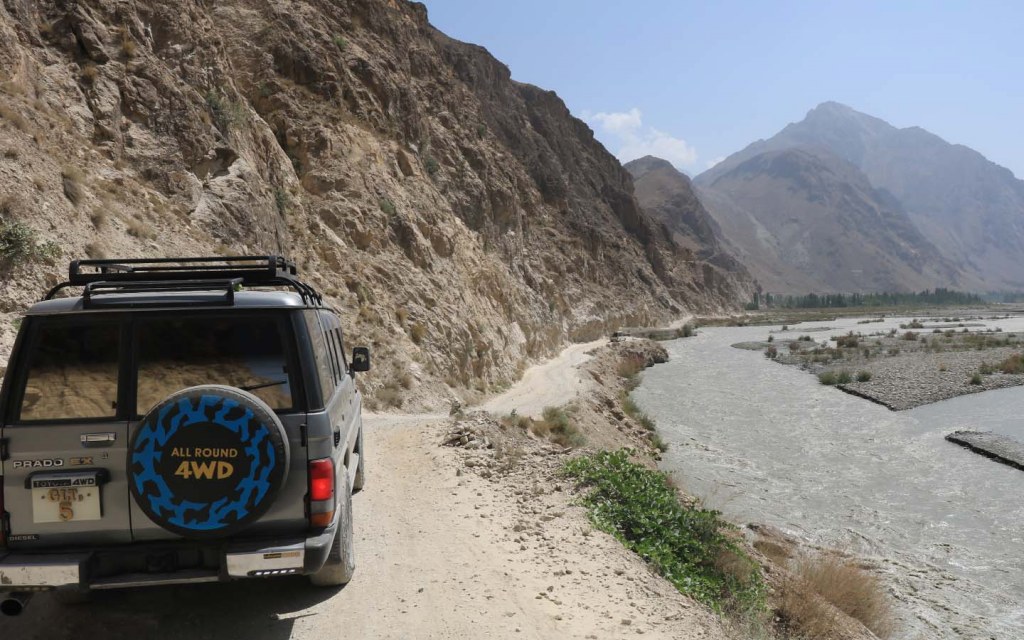
Karakoram Highway
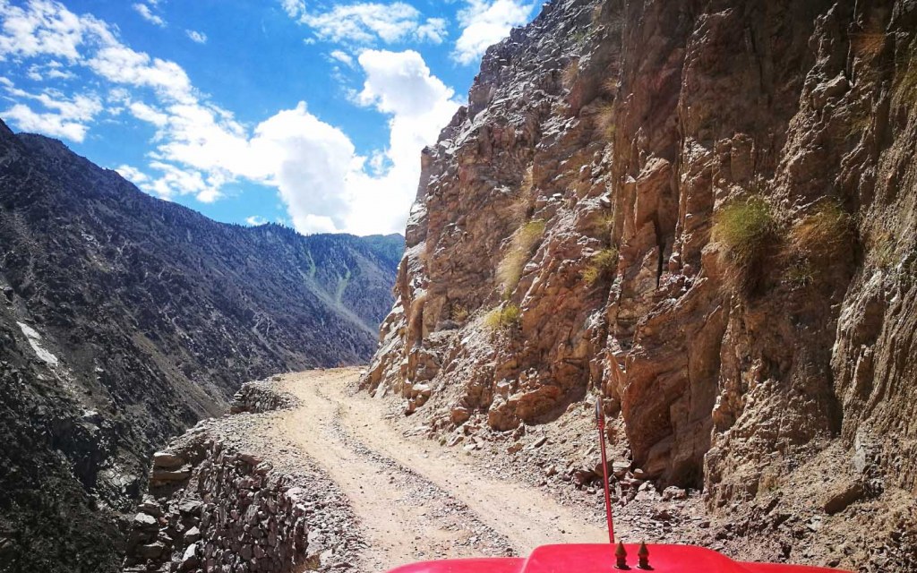
Sheer Drops and Ragged Cliffs Await Travellers on the Karakoram Highway
We start off with the Karakoram Highway
or KKH, which is the highest paved road anywhere in the world. Built
over a period of 27 years, from 1959 to 1986, on the path of the
original Silk Route, the KKH claimed close to 900 lives during its
construction. Most of these were Pakistani workers, while around 80 of
them were Chinese. It is considered one of the scariest roads in the
world, with a length of 1,300 kilometres. Heights, hairpin turns, and
steep cliffs await you here.
Considering the route it takes, the KKH is also susceptible to bad
weather, resulting in avalanches, landslides, and heavy snowfall, all of
which can block the route for days. The part of the KKH leading to
Khunjerab Pass is particularly challenging, having only enough space for
a single jeep to pass through with a sheer drop at one end and a rough
rock face on the other. The drive should definitely not be attempted by
novice drivers, and the vehicle should be reasonably equipped to handle
emergencies before traversing the route.
Fairy Meadows Track
The Jeep Will Only Take You So Far, So Be Prepared to Hike Uphill on the Track to Fairy Meadows
Beginning at Raikot Bridge on the Karakoram Highway, the
16.2-kilometre track leads all the way to the village of Tato, at the
height of 3,300 metres (nearly 10,800 feet) above sea level. The road is
unpaved, uneven, and risky, with a jeep crawling along at a cautious
pace to avoid falling into the abyss below. The route is certainly not
for the faint-hearted and is often listed as one of the scariest roads
in the world. But it’s not the drive that’s the scary part, it’s the
last two kilometres of the track, where the path becomes so narrow that
no vehicle can pass through it.
You will have to dismount here and then hike to the top. The journey
is of around 2 hours, but it can be the scariest two hours of your life,
with one wrong step sending gravel tumbling down the cliff. You can
make this part of the journey on horseback if trekking uphill is too
much of a challenge. The region is closed off in the winters due to
snowfall and avalanches, and the journey can only be made in the summer
months of June and July. So, are you prepared to risk it all to witness
beauty beyond compare?
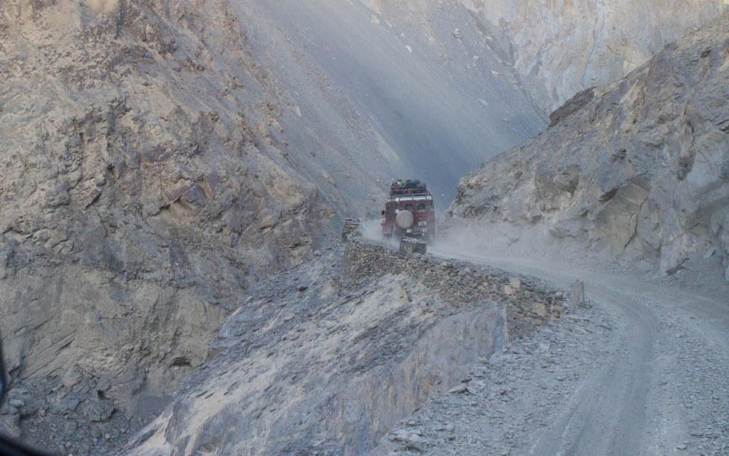
Shimshal Valley Road
The Residents of Shimshal Finally Have a Road, But It Doesn’t Make the Journey Any Safer!
Shimshal is the highest settlement in Hunza Valley, with an altitude
of 3,100 metres (10,200 feet approx.). The settlement was inaccessible
by road until as recent as October 2003. This was when a road, which was
under construction for 18 years, finally got completed and was then
inaugurated. Before the route was built, residents of Shimshal had to
undertake a 3-day journey over 3 mountain passes under extreme weather
conditions to reach the nearest village of Passu (at the height of 2,485
metres or 8,150 feet approx.) and even now, it is one of the most
perilous roads in Pakistan, and only experienced jeep drivers undertake
the journey.
One vehicle usually leaves Shimshal every morning, taking all the
passengers to Passu and returning again in the evening, but with no
guard rails on the road and having to cross some scary wooden bridges
and gorges just to get to another settlement, few want to traverse on
the route regularly. The route is 56 kilometres long, but the permitted
speed of the vehicle is around 10 kilometres per hour, so you should
only experience this thrill if you’re willing to spend five hours on
this dangerous path that even the locals fear.
Jalkhad-Sharda Road
The View’s Great But You Need Nerves of Steel to Traverse This Route!
Linking Jalkhad in Naran Valley to Sharda in Kashmir Valley, the
48.7-kilometre long road rises up to an elevation of 3,960 metres
(13,000 feet), reaching the mountain peak known as Noori Top. Built by
the Pakistan Army in 1998 for use during the Kargil War, the route,
which is among the most treacherous tracks of Pakistan, is now a tourist
spot for adventure seekers.
The view along the way is fabulous, with the Naran Valley on one side
and the Kargil Mountains and Kashmir on the other, but it’s only
possible to enjoy the view if you ignore the sheer drops that run
alongside the road at every hairpin turn. Weather constraints often
result in a closure of the route for most of the year, so July to
September is the best time to enjoy this thrilling and death-defying
ride to the top. Make sure your 4×4 is driven by an experienced local as
they know how to navigate these roads best.
Gilgit-Skardu Road
Cut From the Mountains Itself, This Road is Prone to Landslides and Has Many Hairpin Turns
Known as Strategic Highway 1 or S-1, the route begins on the
Karakoram Highway in Gilgit, ending after a distance of 167 kilometres
in Skardu. The incline takes passengers from a height of 1,500 metres
(4,900 feet) to 2,200 metres (7,300 feet) above sea level, running
alongside the River Indus. Constructed in 1982 by the Pakistan Army
engineers in association with engineers from China, the road was
originally unpaved, with rough gravel and landslides making the journey
difficult.
While sections of the road have now been paved, the journey is still 8
hours long, and rough weather can block the road for up to weeks at a
time. The rocky, rugged, and barren mountains in the region also make
the journey challenging for those who face carsickness or
claustrophobia, as the route is generally open only in the summer months
when the barren surroundings can result in an unbearable heatwave
combined with the gradual incline of the route. For those who dare, the
views are amazing with the road passing by several suspension bridges,
quaint villages, and valleys.
Shounter Pass
The Shounter Pass Takes You Through This Lush Green Valley, Up to Shounter Lake
Another unpaved route among the most dangerous roads of Pakistan is
the one leading to Shounter Valley. Commonly known as Shounter Pass, the
route is located in Neelum Valley, Azad Kashmir, at an elevation of
4,400 metres (14,500 feet). Open for only a few months every year, the
pass takes you from Kel in a jeep through the valley, where panoramic
views, pine forests, and towering hills await you with the Neelum River
keeping you company. Enthusiasts often drive on this daring route to
reach Shounter Lake, which is half-way up the valley.
Babusar Pass
The Babusar Pass Leading to Chilas in Kaghan Valley
Chilas in Kaghan Valley connects to the Karakoram Highway via Babusar
Pass, a road that was known for its slippery, sliding gravel that could
shake nerves of steel. While the road has now been paved, it is still
famous for its curvy bends and is generally open from July to September,
after which, winter weather results in a closure of the route.
Although the incline takes you up to 4,200 metres (13,700 feet), it
is the decline that is the challenge for even the most experienced of
drivers, especially considering the unexpected weather conditions that
the region is known for and the sheer drops at every turn.
Shandur Pass
Many Polo Enthusiasts Journey on This Route Every Year
Have you heard about the Shandur Polo Festival
that is held every year at the highest polo ground in the world? If you
haven’t, let’s just say that you’re missing out on a real treat as
traversing the route to the polo ground is an adrenaline-pumping journey
in itself. The Shandur Pass lies at an elevation of 3,700 metres
(12,200 feet) in Chitral Valley, with the jeep traversing across a steep
unpaved incline to reach the flat plateau at the top where the sport is
played.
Often called the ‘Roof of the World’, you can only reach Shandur via
this route in May to October, and you’ll need to hold on to your seat
because the cliffs on one side of the road will have you praying for
your safe arrival at your destination.
These are some of the most dangerous roads of Pakistan, where
thrill-seeking tourists can often be found daring it all for the
experience. But for the locals, the routes are a part of their everyday
lives, where they take life into their own hands to travel from one
settlement to the other over unpaved and steep roads that genuinely
deserve a place on our list.


